At Point Reyes, California, the San Andreas Fault exits the North American
Continent and extends seaward where it eventually joins the Mendocino Fracture
Zone and the Gorda Ridge (a segment of a mid-ocean spreading center or divergent
plate boundary).
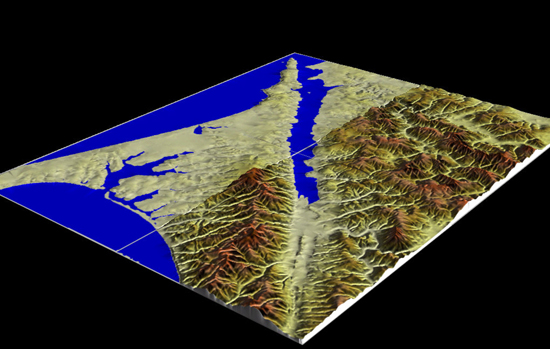
The image on this page shows very clearly the trace of the San Andreas Fault
zone as it passes through the Pt. Reyes area and heads out to sea - you are
looking toward the northwest down the axis of a valley defined by the San
Andreas Fault.
 <a onClick="window.open('/olcweb/cgi/pluginpop.cgi?it=jpg:: ::/sites/dl/free/0072402466/30425/VirtualVista1601.jpg','popWin', 'width=NaN,height=NaN,resizable,scrollbars');" href="#"><img valign="absmiddle" height="16" width="16" border="0" src="/olcweb/styles/shared/linkicons/image.gif"> (146.0K)</a>
Pt. Reyes itself (on the left side of this image) is part of the Pacific
Plate, and is being translated southeastward along the transform plate boundary
marked by the San Andreas Fault Zone. The right side of the image is part
of the North American Plate and is being translated northwestward relative
to Pt. Reyes.
To learn more about the San Andreas Fault in California, read the online
publication "The San Andreas
Fault" by the United States Geological
Survey.