The seafloor remains among the most inaccessible regions of our planet. Even
though at least 70% of Earth's surface is composed of oceanic crustal rocks,
only a small portion of the global seafloor has been mapped in detail. Seafloor
geologic processes are intimately connected to the global plate tectonic system,
and understanding seafloor geologic features was critical in developing modern
plate tectonic theory.
The Southern California Continental Borderland is a broad area offshore southern
California extending approximately from Santa Barbara to the Mexican border
and seaward from shore approximately 180 km.
The borderland owes its origins to complex tectonic processes associated
first with an ocean-continent convergent boundary, then later development
of the transform boundary separating the Pacific and North American plates.
 <a onClick="window.open('/olcweb/cgi/pluginpop.cgi?it=jpg:: ::/sites/dl/free/0072402466/30425/VirtualVista1801.jpg','popWin', 'width=NaN,height=NaN,resizable,scrollbars');" href="#"><img valign="absmiddle" height="16" width="16" border="0" src="/olcweb/styles/shared/linkicons/image.gif"> (151.0K)</a>
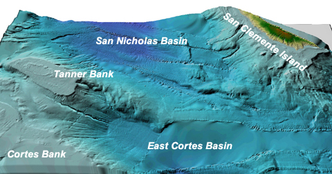
The image above shows a small portion of the Southern California Continental
Borderland approximately 180 km seaward of San Diego. The image was derived
from detailed geophysical surveys and processed using Geographic Information
System (GIS) software. The view is looking northward toward San Clemente Island.
Notice there are several submerged platforms (Tanner and Cortes Banks) and
deep basins (East Cortes and San Nicholas Basins). The basins are up to 1.8
km deep.
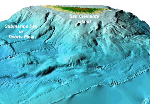
The image below is another virtual view of the borderland looking at the
submarine edifice surrounding San Clemente Island. Notice that the exposed
portion of the island is only a small part of the actual island platform.
Also note an apparent submarine fan or submarine debris flow associated with
the submarine canyon on the northwest end of San Clemente Island.
 <a onClick="window.open('/olcweb/cgi/pluginpop.cgi?it=jpg:: ::/sites/dl/free/0072402466/30425/VirtualVista1802.jpg','popWin', 'width=NaN,height=NaN,resizable,scrollbars');" href="#"><img valign="absmiddle" height="16" width="16" border="0" src="/olcweb/styles/shared/linkicons/image.gif"> (200.0K)</a>
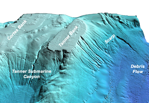
Cortes and Tanner Banks are isolated platforms bound by faults. They are
not presently exposed above sea-level, but rise to within <10 meters of
the sea surface. Both of these platforms were exposed above sea-level during
the last major glaciation, and their flat tops suggest wave erosion as sea-level
rose at the end of the last ice age. Not also the Tanner Submarine Canyon
leading to the East Cortes Basin.
 <a onClick="window.open('/olcweb/cgi/pluginpop.cgi?it=jpg:: ::/sites/dl/free/0072402466/30425/VirtualVista1803.jpg','popWin', 'width=NaN,height=NaN,resizable,scrollbars');" href="#"><img valign="absmiddle" height="16" width="16" border="0" src="/olcweb/styles/shared/linkicons/image.gif"> (193.0K)</a>
Finally, observe the ragged scarp near the base of Tanner Bank. This scarp
marks the initiation point of a large submarine landslide/debris flow. Material
from this slide extended outward over most of San Nicholas Basin. What factors
might have triggered this event?
The Southern California Continental Borderland is a remarkable geologic province
associated with the present-day transform boundary separating the Pacific
and North American plates. Its origins are best understood in the context
of the Theory of Plate Tectonics.