Site MapHelpFeedbackVirtual Vista
Virtual Vista
(See related pages)

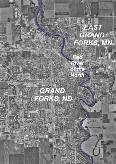
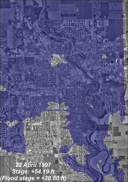
Virtual Vista: Red River of the North, North Dakota and Minnesota, USA

Rivers systems are powerful forces of landscape evolution and change on Earth. The abundance of water on Earth guarantees a large number of major river systems whose flowing water continually erodes material from the continents and transports the sediment to the ocean basins.

This virtual vista illustrates a feature of all major river systems - floods. The frequencies and magnitudes of floods along rivers are controlled by many natural and human factors. Among the human factors contributing to flooding are agricultural practices, channelizing of rivers and levee building projects, urbanization, and land clearing. The image on this page was created by draping digital aerial photographs of Grand Forks, North Dakota and East Grand Forks, Minnesota over a digital elevation model of the same region. The Red River of the North, which forms the boundary between North Dakota and Minnesota in the United States, crosses north-south through the eastern third of the image. Blue color was added to highlight the river course.

<a onClick="window.open('/olcweb/cgi/pluginpop.cgi?it=jpg::Red River of the North::/sites/dl/free/0072826967/90780/1997RedRiverFlood0003.JPG','popWin', 'width=390,height=590,resizable,scrollbars');" href="#"><img valign="absmiddle" height="16" width="16" border="0" src="/olcweb/styles/shared/linkicons/image.gif">Red River of the North (301.0K)</a>Red River of the North

In April 1997, the Red River of the North experienced one of its largest floods since record keeping began in the 1800's. At it's peak, the river level stood at +54.19 feet (28 feet above flood stage), inundating approximately 85% of Grand Forks, ND and nearly 100% of East Grand Forks, MN. The image below shows the extent of flood water (blue shading) on April 22, 1997 showing the near total inundation of these two communities.

<a onClick="window.open('/olcweb/cgi/pluginpop.cgi?it=jpg::Red River Flood 1997::/sites/dl/free/0072826967/90780/RedRiver19970422.JPG','popWin', 'width=390,height=590,resizable,scrollbars');" href="#"><img valign="absmiddle" height="16" width="16" border="0" src="/olcweb/styles/shared/linkicons/image.gif">Red River Flood 1997 (278.0K)</a>Red River Flood 1997

Click on the link below to view time-lapsed images showing the progress of the great flood of 1997 along the Red River of the North.

Red River Flood 1997 Fly By (534.0K)

As you view the movie, consider these Points to Ponder:

1. Use the Internet to locate the elevation of Grand Forks, East Grand Forks, and the Red River of the North. At the peak of the 1997 flood, how deep was the standing water in each community?

2. As you watch the movie, notice that flood waters appear in the center of the city before the Red River overtops its levees. Can you think of an explanation for this type of flooding?

Having trouble loading or viewing the video clip? You will need the DivX video codec for your media player to watch the video. The DivX codec is available free from www.divx.com. Click on the link or type the URL into your browser to go to the DivX download site. Once at the DivX site, follow the "DOWNLOAD" links until you locate the download "Standard DivX Codec (FREE)" hyperlink. Click on the link and download the small DivX codec file. The codec file may take a few minutes to load. Please be patient. Once the file is downloaded to your local computer, double click on the file to automatically install the Divx codec.

You may also discover that the Virtual Vistas work best with the Windows Media Player, available as a free download from www.microsoft.com. Click on the link or type the URL into your browser to go to the Microsoft web site. Once at the web site, type "windows media player" into the Search box, then click on the appropriate link to download the latest version of Windows Media Player.


Physical Geo: Earth RevealedOnline Learning Center

Home > Chapter 16 > Virtual Vista