Web Page Questions: Answer the following questions using the web pages listed in the chapter. 1. How Far Is It? - http://www.indo.com/distance
Using the information on the web site, find the distances and the direction
one would set off in for the following pairs of cities.
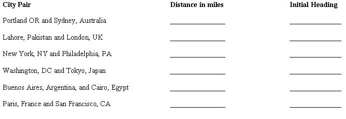 <a onClick="window.open('/olcweb/cgi/pluginpop.cgi?it=jpg::City Pairs::/sites/dl/free/0072367229/9462/Image02_01.jpg','popWin', 'width=710,height=256,resizable,scrollbars');" href="#"><img valign="absmiddle" height="16" width="16" border="0" src="/olcweb/styles/shared/linkicons/image.gif">City Pairs (19.0K)</a>City Pairs <a onClick="window.open('/olcweb/cgi/pluginpop.cgi?it=jpg::City Pairs::/sites/dl/free/0072367229/9462/Image02_01.jpg','popWin', 'width=710,height=256,resizable,scrollbars');" href="#"><img valign="absmiddle" height="16" width="16" border="0" src="/olcweb/styles/shared/linkicons/image.gif">City Pairs (19.0K)</a>City Pairs 2. U.S.G.S. National Mapping Information - http://mapping.usgs.gov/ (Click on "search," then ask for "elevations and distances.")
Find the geographic centers of the following areas: 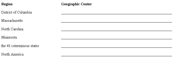 <a onClick="window.open('/olcweb/cgi/pluginpop.cgi?it=jpg::Geographic Center::/sites/dl/free/0072367229/9462/image02_02.jpg','popWin', 'width=712,height=264,resizable,scrollbars');" href="#"><img valign="absmiddle" height="16" width="16" border="0" src="/olcweb/styles/shared/linkicons/image.gif">Geographic Center (13.0K)</a>Geographic Center <a onClick="window.open('/olcweb/cgi/pluginpop.cgi?it=jpg::Geographic Center::/sites/dl/free/0072367229/9462/image02_02.jpg','popWin', 'width=712,height=264,resizable,scrollbars');" href="#"><img valign="absmiddle" height="16" width="16" border="0" src="/olcweb/styles/shared/linkicons/image.gif">Geographic Center (13.0K)</a>Geographic Center
Problems: 1. Geographic Information Systems (GIS) are means of storing and manipulating
geographic information in a computer. With a GIS, data can be analyzed and displayed
with a greater speed and precision than what was possible before their development.
This has become particularly useful to researchers who must combine and analyze
a large number of variables simultaneously. In order to show one of the ways
in which a GIS can be manipulated, combine the following two maps below in order
to create a composite, and then answer the following questions. Note: record
the amount of time it took you to complete the job. 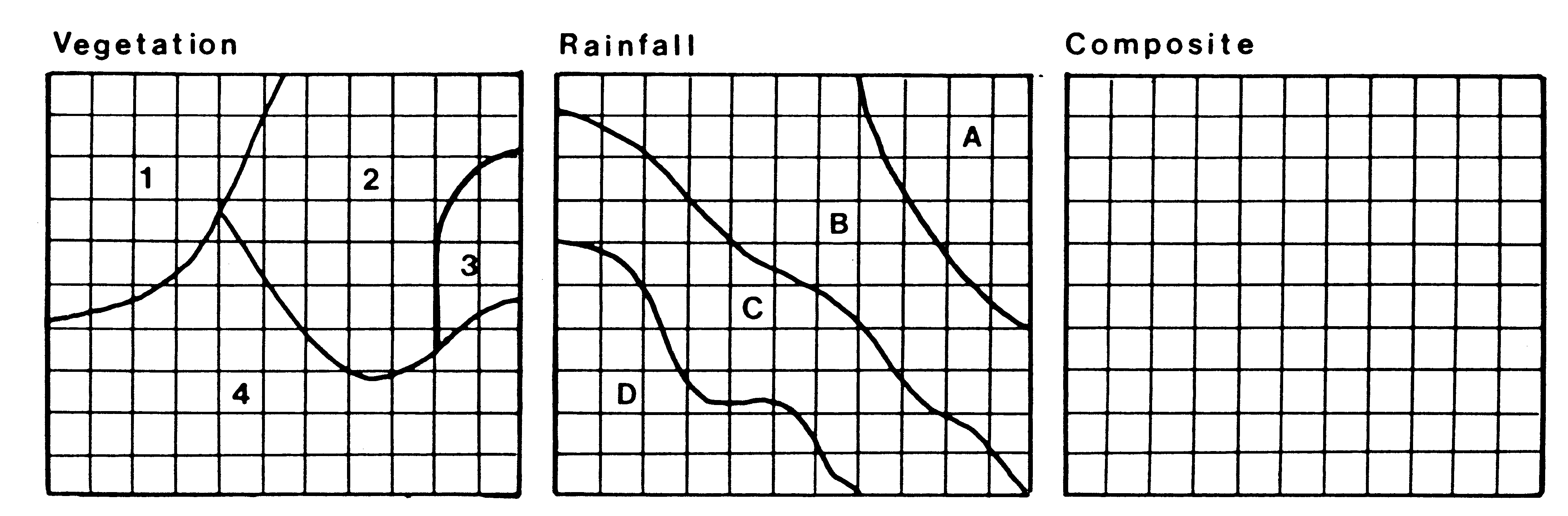 <a onClick="window.open('/olcweb/cgi/pluginpop.cgi?it=gif::Composite Map::/sites/dl/free/0072367229/9462/Image02_03.gif','popWin', 'width=455,height=160,resizable,scrollbars');" href="#"><img valign="absmiddle" height="16" width="16" border="0" src="/olcweb/styles/shared/linkicons/image.gif">Composite Map (121.0K)</a>Composite Map <a onClick="window.open('/olcweb/cgi/pluginpop.cgi?it=gif::Composite Map::/sites/dl/free/0072367229/9462/Image02_03.gif','popWin', 'width=455,height=160,resizable,scrollbars');" href="#"><img valign="absmiddle" height="16" width="16" border="0" src="/olcweb/styles/shared/linkicons/image.gif">Composite Map (121.0K)</a>Composite Map- You have combined the two maps showing rainfall and vegetation. What patterns
appeared once these two maps were overlaid? _______________________________________________________________________________________
_______________________________________________________________________________________
_______________________________________________________________________________________
_______________________________________________________________________________________
- How long did it take you? Relate that to the fact that the computer can
do this instantaneously. _______________________________________________________________________________________
_______________________________________________________________________________________
- How accurate do you feel your drawing is compared to what a computer might
accomplish? _______________________________________________________________________________________
_______________________________________________________________________________________
- Consider each one of the squares in the grid to be a pixel. How would the
accuracy of the map change if the
i. pixels were smaller in size?____________________________________________________________
ii. pixels were larger in size?____________________________________________________________
2. Draw the profile of the island which corresponds to the contour
lines (beginning at sea level and assuming a 100 foot contour interval).
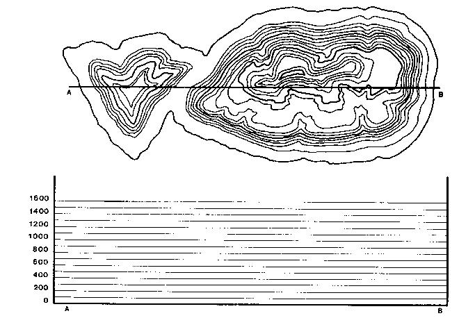 <a onClick="window.open('/olcweb/cgi/pluginpop.cgi?it=jpg::Contour Map::/sites/dl/free/0072367229/9462/image02_04.jpg','popWin', 'width=699,height=474,resizable,scrollbars');" href="#"><img valign="absmiddle" height="16" width="16" border="0" src="/olcweb/styles/shared/linkicons/image.gif">Contour Map (76.0K)</a>Contour Map <a onClick="window.open('/olcweb/cgi/pluginpop.cgi?it=jpg::Contour Map::/sites/dl/free/0072367229/9462/image02_04.jpg','popWin', 'width=699,height=474,resizable,scrollbars');" href="#"><img valign="absmiddle" height="16" width="16" border="0" src="/olcweb/styles/shared/linkicons/image.gif">Contour Map (76.0K)</a>Contour Map 3. Complete the following table, identifying the characteristics of the map
projections.| | Mercator | Conic | Planar | Goode's Homolosine | How is the geographic grid represented? | | | | | | Is the projection equivalent? | | | | | | Is the projection equidistant? | | | | | | What portion of the globe is best depicted? | | | | | | What is the best or most common use of this projection? | | | | |
Critical Thinking Questions
- A map's scale, projection and symbolization are important for both the cartographer
and the reader. Explain how the cartographer is influenced by the choices
available and how the reader can be influenced by the combination used by
the cartographer.
- Nowadays, people are so caught up with the use Internet resources to get
information and with computer programs to analyze numeric data, that they
forget basic research methodology. Why does library research, either manual
or electronic, still play an important role in geographic research?
- Imagine the United States west of the Mississippi River without a township
and range system of land division. How different would the political and cultural
landscape be if township and range had not been employed?
- You have been given the task of supervising a team who will portray recently
acquired information in map format. Since every map should contain basic components
to allow the reader to interpret what is being presented, describe how would
you instruct your staff to prepare the map to receive the data. List ten of
the major components found on any map and explain why each is important and
cannot be omitted.
- Space photography has helped to improve our knowledge of the earth's surface.
By what means has remotely sensed imagery enhanced our understanding of our
planet?
|


 2002 McGraw-Hill Higher Education