Web Page Questions: Answer the following questions using the web pages listed in the chapter.
1. Michigan Tech Volcanoes Page - http://www.geo.mtu.edu/volcanoes- How long has the Pu'u 'O'o eruption of Kilauea been going on?_________________________________
- Which region of the world has the largest number of active volcanoes?____________________________
2. Earthquake Information U.S.G.S. Geologic Division - http://quake.wr.usgs.gov When was the most recent earthquake for the following regions? - Pacific Northwest____________________________________________________________
- Central United States_________________________________________________________
- New York and New England____________________________________________________
Problems: 1. The table on the following page lists all earthquakes measuring at least
5.0 on the Richter Scale which have occurred between 1994 and 1996. The next
page contains a world map with the lithospheric plate boundaries superimposed
as dashed lines. In conjunction with the table and the map, complete the following:
- Classify all the earthquakes by the time period in which they happened.
Use the three time periods below, and assign to each earthquake an appropriate
map symbol according to the following:
 <a onClick="window.open('/olcweb/cgi/pluginpop.cgi?it=jpg::Year Symbols::/sites/dl/free/0072367229/9463/image03_01.jpg','popWin', 'width=566,height=60,resizable,scrollbars');" href="#"><img valign="absmiddle" height="16" width="16" border="0" src="/olcweb/styles/shared/linkicons/image.gif">Year Symbols (1.0K)</a>Year Symbols <a onClick="window.open('/olcweb/cgi/pluginpop.cgi?it=jpg::Year Symbols::/sites/dl/free/0072367229/9463/image03_01.jpg','popWin', 'width=566,height=60,resizable,scrollbars');" href="#"><img valign="absmiddle" height="16" width="16" border="0" src="/olcweb/styles/shared/linkicons/image.gif">Year Symbols (1.0K)</a>Year Symbols- At each location on the map where an earthquake
was recorded, place the appropriate symbol according to the time period in which
the earthquake occurred.
- For each of the three time periods, what area or areas of the world were
the most active earthquake zones, and what plate boundaries correspond to those
zones?
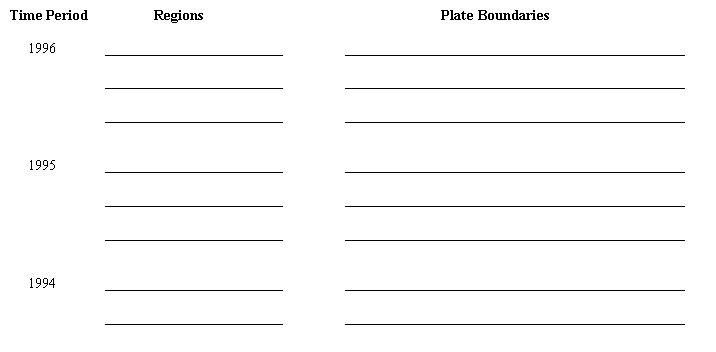 <a onClick="window.open('/olcweb/cgi/pluginpop.cgi?it=jpg::Time Periods::/sites/dl/free/0072367229/9463/image03_02.jpg','popWin', 'width=732,height=368,resizable,scrollbars');" href="#"><img valign="absmiddle" height="16" width="16" border="0" src="/olcweb/styles/shared/linkicons/image.gif">Time Periods (11.0K)</a>Time Periods <a onClick="window.open('/olcweb/cgi/pluginpop.cgi?it=jpg::Time Periods::/sites/dl/free/0072367229/9463/image03_02.jpg','popWin', 'width=732,height=368,resizable,scrollbars');" href="#"><img valign="absmiddle" height="16" width="16" border="0" src="/olcweb/styles/shared/linkicons/image.gif">Time Periods (11.0K)</a>Time Periods
Major Earthquakes since January 1, 1994 | Date | Location | Date | Location | | 1-17-94 | Northridge, California | 9-14-95 | S. Mexico | | 1-19-94 | Irian Jaya, Indonesia | 10-1-95 | SW Turkey | | 1-21-94 | Halmahera, Indonesia | 10-3-95 | Peru-Ecuador border | | 2-15-94 | Sumatra, Indonesia | 10-5-95 | W Sumatra, Indonesia | | 2-15-94 | SW Vanuatu | 10-5-95 | W coast Mexico | | 3-14-94 | Mexico-Guatemala border | 10-18-95 | Ruykyu Islands, Japan | | 6-6-94 | Cauca, SW Colombia | 11-8-95 | N Sumatra, Indonesia | | 6-9-94 | La Paz, Bolivia | 11-22-95 | Aqaba, Jordan | | 8-19-94 | N Algeria | 12-3-95 | Kuril Islands | | 1-17-95 | Kobe, Japan | 1-1-96 | Sulawesi Island, Indonesia | | 5-27-95 | Sakhalin Island, Russia | 2-7-96 | Kuril Islands | | 7-3-95 | Kermadec Island, New Zealand | 2-25-96 | W Mexico | | 7-11-95 | E Myanmar | 4-29-96 | Solomon Islands | | 7-30-95 | N coast Chile | 6-10-96 | Aleutian Islands | | 8-16-95 | Papua New Guinea | 6-11-96 | Samar Island, Philippines |
Source: 1997 World Almanac and Book of Facts 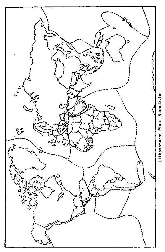 <a onClick="window.open('/olcweb/cgi/pluginpop.cgi?it=jpg::Plate Boundaries::/sites/dl/free/0072367229/9463/image03_03.jpg','popWin', 'width=574,height=868,resizable,scrollbars');" href="#"><img valign="absmiddle" height="16" width="16" border="0" src="/olcweb/styles/shared/linkicons/image.gif">Plate Boundaries (89.0K)</a>Plate Boundaries <a onClick="window.open('/olcweb/cgi/pluginpop.cgi?it=jpg::Plate Boundaries::/sites/dl/free/0072367229/9463/image03_03.jpg','popWin', 'width=574,height=868,resizable,scrollbars');" href="#"><img valign="absmiddle" height="16" width="16" border="0" src="/olcweb/styles/shared/linkicons/image.gif">Plate Boundaries (89.0K)</a>Plate Boundaries2. The three diagrams below contain various landforms that are identified by
the letters A through K.
In the spaces below, write the name of the landform next to the identifying
letter. | A. | | G. | | | B. | | H. | | | C. | | I. | | | D. | | J. | | | E. | | K. | | | F. | |
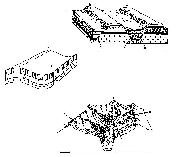 <a onClick="window.open('/olcweb/cgi/pluginpop.cgi?it=jpg::Cross Sections::/sites/dl/free/0072367229/9463/image03_04.jpg','popWin', 'width=593,height=525,resizable,scrollbars');" href="#"><img valign="absmiddle" height="16" width="16" border="0" src="/olcweb/styles/shared/linkicons/image.gif">Cross Sections (48.0K)</a>Cross Sections <a onClick="window.open('/olcweb/cgi/pluginpop.cgi?it=jpg::Cross Sections::/sites/dl/free/0072367229/9463/image03_04.jpg','popWin', 'width=593,height=525,resizable,scrollbars');" href="#"><img valign="absmiddle" height="16" width="16" border="0" src="/olcweb/styles/shared/linkicons/image.gif">Cross Sections (48.0K)</a>Cross SectionsCritical Thinking Questions - Natural geologic processes have been around since the formation of the
planet. Now many of these same processes are considered natural hazards.
Discuss the transformation of a process into a hazard.
- Using Fig. 3.3, the lithospheric plate map as a guide, explain the existence
of volcanoes and volcanic features on the islands of the West Indies and
in Central America.
- If a dam is built across the river shown in Fig. 3.34 what scenario can
you see for the size and shape of the spit and offshore sandbars 25 years
from now?
- With regard to fluctuating sea level over the last 10,000 years, discuss
the present shoreline configuration of the Pacific coast of the United States.
Is sea level higher or lower than it was when the coastal landform features
were created? What would happen if sea level would rise 100 feet? What would
happen if sea level was lowered by 100 feet?
- Study the photographs of earthquake damage in this chapter of the textbook
and those found in photo archives of major earthquakes that occurred over
the last 10 years. While governments worldwide have enacted similar legislation
to make new structures earthquake-proof and older ones more earthquake-resistant,
ultimately the success of these regulations rest with people and not necessarily
the intensity of the earthquake. Why do some smaller (less intense) earthquakes
in some areas cause more damage to existing structures than larger (more
intense) earthquakes in other areas? Compare damage from major earthquakes
in Turkey, Taiwan, India and the United States. While severe damage in unavoidable
with the best of building codes, what did the analysis of the success or
failure of these designs discover?
|


 2002 McGraw-Hill Higher Education