Visualizing and understanding geologic structures is one of the most challenging
tasks facing students in introductory geology courses. In order to comprehend
geologic structures, it is necessary to practice your skills at 3-dimensional
visualization.
Digital technologies are a marvelous way to illustrate the complex 3-dimensional
relationships of strata in geologic structures. A picture may be worth a thousand
words, but a good picture of a geologic structure is priceless.
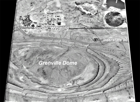
The image below shows Grenville Dome, a small doubly plunging anticline located
near Sinclair, Wyoming, USA. This image was generated using a computer to
process a digital elevation model (DEM), then a digital aerial image was
mapped to the surface to produce this wonderful 3-dimensional image.
 <a onClick="window.open('/olcweb/cgi/pluginpop.cgi?it=jpg:: ::/sites/dl/free/0072402466/30425/VirtualVista1501.jpg','popWin', 'width=NaN,height=NaN,resizable,scrollbars');" href="#"><img valign="absmiddle" height="16" width="16" border="0" src="/olcweb/styles/shared/linkicons/image.gif"> (139.0K)</a>
You can imagine the scale of this structure by noting the 4-lane interstate
highway in this image just north of the structure. Also, the small town of
Sinclair, Wyoming.
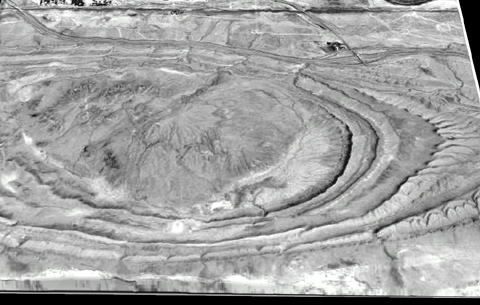
The image below is a close-up virtual view of the Grenville Dome. In this
image, it is evident that the exposed strata are inclined (dipping away from
the center of the structure). Note that the pattern of stream erosion creates
v-shaped notches in the outcrops, and the "v" points in the direction
of plunge. Which strata do you think are oldest in this view? Which are the
youngest? How would you measure the strike of these strata?
 <a onClick="window.open('/olcweb/cgi/pluginpop.cgi?it=jpg:: ::/sites/dl/free/0072402466/30425/VirtualVista1502.jpg','popWin', 'width=NaN,height=NaN,resizable,scrollbars');" href="#"><img valign="absmiddle" height="16" width="16" border="0" src="/olcweb/styles/shared/linkicons/image.gif"> (116.0K)</a>
Folds such as this record intervals of geologic time when tremendous
tectonic stresses occur within the lithosphere. Folding like this is often
associated with large scale mountain building events driven by Plate Tectonic
processes. Thorough analyses of folds across a geographic region can yield
a good deal of information about the geologic history of that area.