Site MapHelpFeedbackVirtual Vista
Virtual Vista
(See related pages)

Virtual Vista: Glacier National Park, Montana, USA

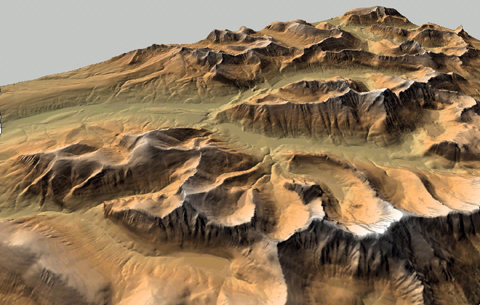
The images of this Virtual Vista represent one of the most breathtaking of the United States national parks - Glacier National Park - which straddles the northern border of the United States and Canada (Waterton Glaciers National Park). Digital terrain models of four 7.5-minute quadrangles located in Glacier National Park, Montana, USA were rendered using Geographic Information System software.

The result is a remarkably realistic looking virtual landscape illustrating many of the alpine glacial landforms you studied in class.

<a onClick="window.open('/olcweb/cgi/pluginpop.cgi?it=jpg::::/sites/dl/free/007252815x/30425/VirtualVista1201.jpg','popWin', 'width=NaN,height=NaN,resizable,scrollbars');" href="#"><img valign="absmiddle" height="16" width="16" border="0" src="/olcweb/styles/shared/linkicons/image.gif"> (97.0K)</a>


<a onClick="window.open('/olcweb/cgi/pluginpop.cgi?it=jpg::::/sites/dl/free/007252815x/30425/VirtualVista1203.jpg','popWin', 'width=NaN,height=NaN,resizable,scrollbars');" href="#"><img valign="absmiddle" height="16" width="16" border="0" src="/olcweb/styles/shared/linkicons/image.gif"> (170.0K)</a>

On the image above, try to identify as many glacial landforms as you can. Some glacial landforms are identified and presented in the image that follows.

<a onClick="window.open('/olcweb/cgi/pluginpop.cgi?it=jpg::::/sites/dl/free/007252815x/30425/VirtualVista1202.jpg','popWin', 'width=NaN,height=NaN,resizable,scrollbars');" href="#"><img valign="absmiddle" height="16" width="16" border="0" src="/olcweb/styles/shared/linkicons/image.gif"> (152.0K)</a>

To learn more about Glacier National Park and the geologic processes that shaped its history, visit the National Park Service website for this park.

Take a virtual flight over a the Many Glaciers area of Glacier National park by clicking on the link below. As you soar over the glacial landscape, try to identify the following alpine glacial landforms: arete, col, tarn, cirque, U-shaped valley, horn, headwall

Glacier NP Fly By (1462.0K)

Points to Ponder:

1. As you view the Virtual Vista, try to identify and name as many glacial landforms as you can.

Can you identify the following landforms?


arete
col
cirque
headwall
horn
tarn
U-shaped valley
hanging valley

Having trouble loading or viewing the video clip? You will need the DivX video codec for your media player to watch the video. The DivX codec is available free from www.divx.com. Click on the link or type the URL into your browser to go to the DivX download site. Once at the DivX site, follow the "DOWNLOAD" links until you locate the download "Standard DivX Codec (FREE)" hyperlink. Click on the link and download the small DivX codec file. The codec file may take a few minutes to load. Please be patient. Once the file is downloaded to your local computer, double click on the file to automatically install the Divx codec.

You may also discover that the Virtual Vistas work best with the Windows Media Player, available as a free download from www.microsoft.com. Click on the link or type the URL into your browser to go to the Microsoft web site. Once at the web site, type "windows media player" into the Search box, then click on the appropriate link to download the latest version of Windows Media Player.


Plummer Physical GeologyOnline Learning Center

Home > Chapter 12 > Virtual Vista