To install the Mastering ArcGIS Pro 1st edition training data: The gisclass_Pro1e.zip archive contains the documents and data needed to do the tutorials and exercises. Each student must extract the contents of this file to his/her own hard drive to create a gisclass folder containing the data for this book. If more than one person on the computer is using this book, then each person should make her own copy of the data in a separate folder. The installed data requires approximately 240 MB of disk space. It is set up as a zip file named gisclass_Pro1e.zip. The file may take several minutes to download, so check your browser to be sure that the download is complete before trying to open or extract the zip file. - It is recommended that you create a folder named gisclass on your computer’s C:\ drive and install the data in it. That way it will match the examples in the book. However, you may install it in any location you wish, as long as it is on the C:\drive. Do not install it in your user Documents folder or on the Desktop, because GIS data often function poorly in those locations.
To install the data for the exercises using the Windows 10 File Explorer, - Double-click the gisclass_Pro1e.zip file. An Extract menu will appear at the top of the File Explorer window. Click Extract and then the Extract All button.
- Click the Browse button to specify where to install the data. The data will be placed in a folder called mgisdata in whatever location you choose. In other words, if you select C:\gisclass as the target folder, then the data will be placed in C:\gisclass\mgisdata.
- Click Extract to install the data.
Note: If not using Windows 10, you may need to use a zip program such as 7zip (free) to extract the data. Download it, install it on your computer, and follow its instructions to extract the mgisdata file from gisclass_Pro1e.zip. Step 1. Click the gisclass_Pro1e.zip file to open the Extract menu in Windows 10 File Explorer 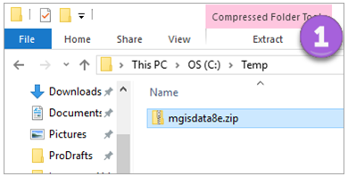 <a onClick="window.open('/olcweb/cgi/pluginpop.cgi?it=png::::/sites/dl/free/1260587339/1107015/imagea.png','popWin', 'width=NaN,height=NaN,resizable,scrollbars');" href="#"><img valign="absmiddle" height="16" width="16" border="0" src="/olcweb/styles/shared/linkicons/image.gif"> (28.0K)</a> <a onClick="window.open('/olcweb/cgi/pluginpop.cgi?it=png::::/sites/dl/free/1260587339/1107015/imagea.png','popWin', 'width=NaN,height=NaN,resizable,scrollbars');" href="#"><img valign="absmiddle" height="16" width="16" border="0" src="/olcweb/styles/shared/linkicons/image.gif"> (28.0K)</a>Steps 2-3. Specify where to save the folder and click Extract. 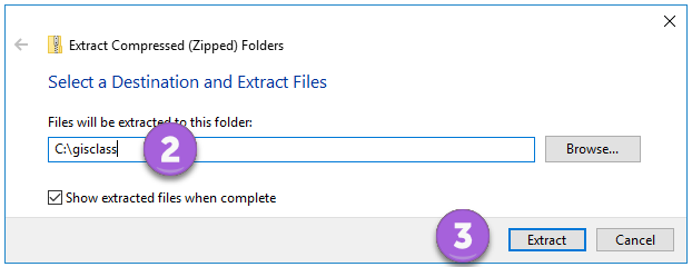 <a onClick="window.open('/olcweb/cgi/pluginpop.cgi?it=png::::/sites/dl/free/1260587339/1107015/imageb.png','popWin', 'width=NaN,height=NaN,resizable,scrollbars');" href="#"><img valign="absmiddle" height="16" width="16" border="0" src="/olcweb/styles/shared/linkicons/image.gif"> (13.0K)</a> <a onClick="window.open('/olcweb/cgi/pluginpop.cgi?it=png::::/sites/dl/free/1260587339/1107015/imageb.png','popWin', 'width=NaN,height=NaN,resizable,scrollbars');" href="#"><img valign="absmiddle" height="16" width="16" border="0" src="/olcweb/styles/shared/linkicons/image.gif"> (13.0K)</a> |