The Theory of Plate Tectonics was formalized during the 1960's, giving geoscientists
a new paradigm with which to explain the observed surface features, geological
phenomena, and geologic history of Earth.
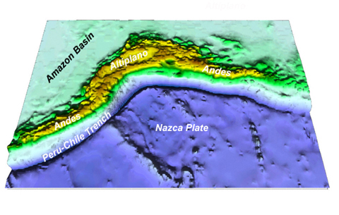
The image below shows a digital elevation model of the western margin of
South America viewed from the west (i.e. over the Pacific Ocean looking east).
The western margin of South America is a type-example of an Ocean-Continent
Convergent Plate Boundary. The oceanic Nazca Plate (below) represents ocean
lithosphere generated at the East Pacific Rise in the Pacific Ocean Basin.
As the Nazca Plate spreads eastward, it encounters the South American Plate
moving westward from the Mid-Atlantic Ridge.
 <a onClick="window.open('/olcweb/cgi/pluginpop.cgi?it=jpg:: ::/sites/dl/free/0072402466/30425/VirtualVista1901.jpg','popWin', 'width=NaN,height=NaN,resizable,scrollbars');" href="#"><img valign="absmiddle" height="16" width="16" border="0" src="/olcweb/styles/shared/linkicons/image.gif"> (129.0K)</a>
Where the two plates collide, a number of important geologic features develop.
Along the collision boundary, the oceanic Nazca Plate is overridden or subducted
beneath the South American Plate. At the contact of this collision zone, a
deep ocean trench (Peru-Chile Trench above) forms. Landward of the collision
zone, a steep, rugged mountain range (the Andes) forms as the South American
Plate is deformed by plate convergence.
 <a onClick="window.open('/olcweb/cgi/pluginpop.cgi?it=jpg:: ::/sites/dl/free/0072402466/30425/VirtualVista1902.jpg','popWin', 'width=NaN,height=NaN,resizable,scrollbars');" href="#"><img valign="absmiddle" height="16" width="16" border="0" src="/olcweb/styles/shared/linkicons/image.gif"> (111.0K)</a>
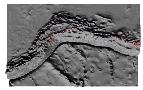
The Andes Mountains are complex, formed of both folded mountains and active
volcanoes. As a result of subduction of the Nazca Plate, magma forms in the
asthenosphere beneath South America and gives rise to andesitic volcanoes.
The image above shows those volcanoes in the central Andes that have been
active in historic times (red stars).
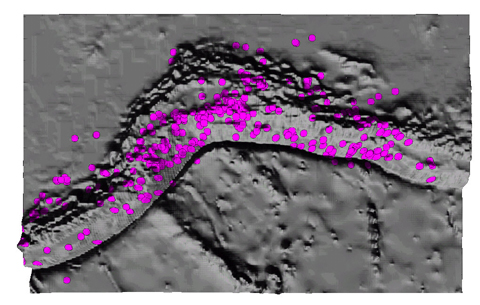
Another characteristic feature of convergent plate margins is the occurrence
of numerous earthquakes, some of which can attain very large magnitudes (the
1960 Chile earthquake is among the most powerful ever recorded). The image
below shows the distribution of earthquakes for a single year. Note that the
earthquake zone is generally limited to the continental plate - why do you
think this is so?
 <a onClick="window.open('/olcweb/cgi/pluginpop.cgi?it=jpg:: ::/sites/dl/free/0072402466/30425/VirtualVista1903.jpg','popWin', 'width=NaN,height=NaN,resizable,scrollbars');" href="#"><img valign="absmiddle" height="16" width="16" border="0" src="/olcweb/styles/shared/linkicons/image.gif"> (139.0K)</a>
The Theory of Plate Tectonics provided a more thorough explanation of the
causes of volcanic eruptions and earthquakes in South America. In a similar
way, explanations of geologic phenomena around the world were explained by
reference to the Plate Tectonic model of Earth dynamics.
To learn more about Plate Tectonics and how geologists have been able to
use this theory to explain much of Earth's history, go the Internet and read
"This Dynamic
Earth" available from the United States
Geological Survey.