The Theory of Plate Tectonics was formalized during the 1960's, giving geoscientists
a new paradigm with which to explain the observed surface features, geological
phenomena, and geologic history of Earth.
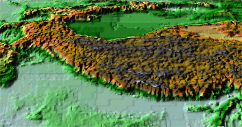
The image below shows a digital elevation model of the Himalayas, the tallest
mountain range in the world. The Himalayas are the type-example of a Continent-Continent
Convergent Plate Boundary. Even as you are reading this, the Himalayas are
being uplifted as India collides with southern Asia. This collision is driven
by the relative motion of the Indian Plate northward.
 <a onClick="window.open('/olcweb/cgi/pluginpop.cgi?it=jpg:: ::/sites/dl/free/0072402466/30425/VirtualVista2001.jpg','popWin', 'width=NaN,height=NaN,resizable,scrollbars');" href="#"><img valign="absmiddle" height="16" width="16" border="0" src="/olcweb/styles/shared/linkicons/image.gif"> (170.0K)</a>
Note how the Himalayas rise rapidly in northern India and the broad uplift
of the regions to the north as an elevated plateau. The Himalayas are a complexly
folded and uplifted series of mountain ranges - a hint of this structure is
evident by examining the gray bands (representing the highest mountains) in
the image above.
 <a onClick="window.open('/olcweb/cgi/pluginpop.cgi?it=jpg:: ::/sites/dl/free/0072402466/30425/VirtualVista2002.jpg','popWin', 'width=NaN,height=NaN,resizable,scrollbars');" href="#"><img valign="absmiddle" height="16" width="16" border="0" src="/olcweb/styles/shared/linkicons/image.gif"> (192.0K)</a>
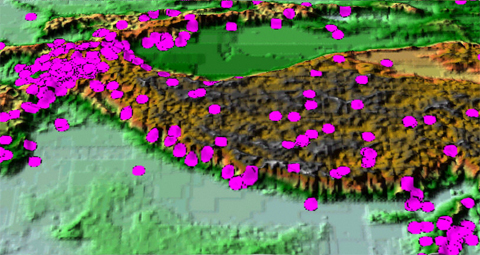
A characteristic feature of continent-continent convergent plate boundaries
is the occurrence of numerous earthquakes (some of which can attain large
magnitudes) but an absence of volcanic activity (unlike other convergent plate
margins). The image above shows epicenters of earthquakes across the Himalayan
region for a single year. Note the extreme earthquake activity in the western
Himalayas.
The Theory of Plate Tectonics provided a more thorough explanation of the
causes of earthquakes and mountain uplift in the Himalayas. In a similar
way, explanations of geologic phenomena around the world were explained by
reference to the Plate Tectonic model of Earth dynamics.
To learn more about Plate Tectonics and how geologists have been able to
use this theory to explain much of Earth's history, go the Internet and read
"This Dynamic
Earth" available from the United States
Geological Survey.

