The seafloor remains among the most inaccessible regions of our planet. Even
though at least 70% of Earth's surface is composed of oceanic crustal rocks,
only a small portion of the global seafloor has been mapped in detail.
However, details of the seafloor bathymetry (depth), structure, and geology
began to emerge following World War II as geologists developed a variety of
instruments to measure geophysical properties of the Earth. Even today, geophysical
measurements at sea provide marine geologists with the best information about
geologic processes and phenomena occurring many kilometers beneath the waves.
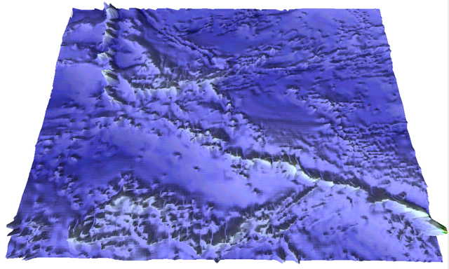
One interesting feature of the seafloor discovered using geophysical data
was the occurrence of long chains of seamounts, especially throughout the
Pacific Ocean basin. The image below shows the longest of these chains composed
of the Hawai'ian archipelago and a chain of submerged mountains known as the
Emperor Seamounts.
 <a onClick="window.open('/olcweb/cgi/pluginpop.cgi?it=jpg::::/sites/dl/free/0072826819/30425/VirtualVista1701.jpg','popWin', 'width=NaN,height=NaN,resizable,scrollbars');" href="#"><img valign="absmiddle" height="16" width="16" border="0" src="/olcweb/styles/shared/linkicons/image.gif"> (271.0K)</a>
The image was derived from a digital elevation model of a portion of the
North Pacific Ocean and rendered using Geographic Information System (GIS)
software. The view is looking northward across the central North Pacific Ocean
basin. The line of mountains extending from the right-hand corner to the left
top of the image is the chain.
The image below is another virtual view of the Hawai'i - Emperor Seamounts,
with prominent seamounts labeled. This view looks northwestward along the
axis of the Hawai'ian Seamount chain. Hawai'i and the Hawai'ian Islands are
located near the bottom of the image. Midway Island and several of the Emperor
Seamounts are also labeled.
 <a onClick="window.open('/olcweb/cgi/pluginpop.cgi?it=jpg::::/sites/dl/free/0072826819/30425/VirtualVista1702.jpg','popWin', 'width=NaN,height=NaN,resizable,scrollbars');" href="#"><img valign="absmiddle" height="16" width="16" border="0" src="/olcweb/styles/shared/linkicons/image.gif"> (202.0K)</a>
Each of these seamounts is a shield volcano formed as the Pacific Plate moved
first northward then northwestward over the Hawai'ian Hotspot, a plume of
asthenosphere rising from deep within Earth's mantle.
Geophysical observations such as those used to document these seamounts were
crucial in developing and confirming the Theory of Plate Tectonics.
The early hypothesis of continental drift proposed by Alfred Wegener has
given way to the Theory of Plate Tectonics. This theory is (as described in
Chapter 19 of your textbook) the unifying theory of Geology, and provides
Earth scientists with a context for understanding the geological history of
our planet. Plate Tectonic theory has been confirmed by many observations
during the last 40 years or so.
Among the unique capabilities that the understanding of Plate Tectonics has
given geologists is the ability to reconstruct past positions of continental
landmasses showing the evolution of those continents from
the supercontinent of Pangea to the present day. Maps of continental positions
are made possible by studies of Earth's magnetism and the geological record
of Earth's magnetic field preserved in igneous and (some) sedimentary rocks.
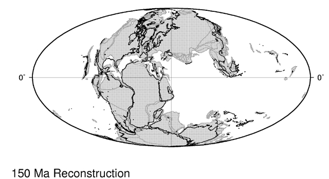 <a onClick="window.open('/olcweb/cgi/pluginpop.cgi?it=jpg::Pangea 150 Million Years Ago::/sites/dl/free/0072826819/90780/PlatesMa150.jpg','popWin', 'width=NaN,height=NaN,resizable,scrollbars');" href="#"><img valign="absmiddle" height="16" width="16" border="0" src="/olcweb/styles/shared/linkicons/image.gif">Pangea 150 Million Years Ago (84.0K)</a>Pangea 150 Million Years Ago
The image above is an reconstruction of Pangea and the arrangment of continental
landmasses as they appeared 150 million years ago, shortly after the Atlantic
Ocean basin began to open between North America and Africa. The outlines of
the modern continents are indicated with a black border so that you might
recognize this strange planet. Click on the link below to view a Virtual Vista
showing the breakup of Pangea and movement of the continents during the last
150 million years of Earth's history.